The Interstate Highway shields hide within them long forgotten knowledge. As our great ancestors could navigate by the signs in the sky before the creation of the compass, so too before GPS could they navigate by these signs. Come with me and learn how to navigate the constellations created across a continent by the First.
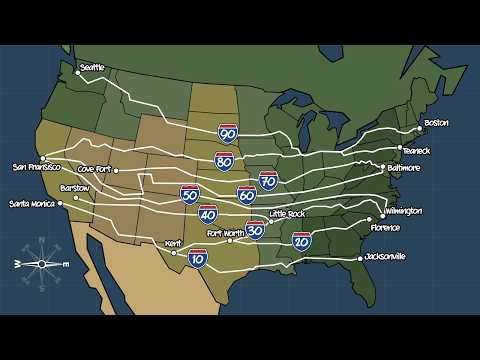
Are the Interstate Majors beginning with I-90 from Seattle to Boston the longest and northern-ist of all the I’s? Then the southern-ist Jacksonville, Florida, to Santa Monica, California: I-10. Interstate Majors that run east-west are double digits ending in zero. The bigger the northern-er. So filling in the rest, the next northern-est is San Francisco, California, to Teaneck, New Jersey: I-80. And the next southern-est Florence, South Carolina, to Kent, Texas: I-20. Then Cove Fort, Utah, to Baltimore, Maryland: I-70, and Little Rock, Arkansas, to Fort Worth, Texas: I-30.
Okay, so that one is the most minor of the Majors, and it doesn’t quite fit as well with the rest with its diagonality. But I’m confident it’s the lone exception and not foreshadowing. Next Barstow, California, to Wilmington, North Carolina: I-40. Then, I-50 and I-60, which don’t exist. See, there are older highways than the Interstate System, slower other ways, not built to the Interstate’s Book of Exalted Construction Codes. These are called US Highways or US Routes, the most famous of which is Route 66. And these use the United States Numbered Highway System which put the old US Route 50 and 60 right in the middle.
The Department of Transportation knew that only the most devout roadway anoraks would be attune to the difference between Interstates and Routes, and normals would simply look at the number. To simplify everyone’s life, DOT skipped Interstates 50 and 60, to avoid minds getting muddled in the middle of ‘Merica.
That’s the East-West Interstates Majors covered. Now on to North-South. The longest of which is Maine to Miami, Florida: I-95. Which, like all majors, no exceptions surely, are double digits, but ending in five now to indicate verticality. On the opposite coast, San Diego, California, to Blaine, Washington is I-5. Okay, so already that’s not double digits, but maybe officially it has a leading zero, but just not on the sign, right, Department of Transportation? No? Okay. Well, then I-5 has a leading zero in our hearts.
The rest of the North-South Interstate Majors are Petersburg, Virginia, to Montgomery, Alabama: I-85, a bit of a sister route to I-30. San Diego, California, to Sweet Grass, Montana: I-15. Sault Ste.Marie, Michigan, to Hialeah, Florida: I-75. Las Cruces, New Mexico, to Buffalo, Wyoming: I-25. Then I-45 from Houston, Texas, to…Dallas, Texas. Contrary to popular belief, interstates don’t have to be interstate interstates, they can be intrastate interstates. The obvious examples are Hawaii and Alaska, which have intrastate interstates, but also Puerto Rico which has an I mean I guess technically it’s an Anyway, these three, being physically disconnected from the rest of the network, use a different numbering system with letters.
But back on the continent, there are in fact way more intrastate interstates than interstate interstates. Most are the Interstate Minors we will get to, but I-45 is notable for being the only Interstate Major that’s intrastate. Finishing up the North-South Majors, it’s Texas again, in Laredo, to Duluth, Minnesota: I-35. Then Chicago, Illinois, to LaPlace, Louisiana: I-55. And finally hop over to Mobile, Alabama, up to Gary, Indiana on I-65.
Together, the Interstate Majors constellation with its shining numbers lets you navigate the nation. The lower the numbers, the more South and West you are. The higher, North and East. If it ends in zero, you’re traveling horizontally. And if it ends in five, vertically. Very satisfying.
Now there are scores of lesser connecting constellations as well. These are Interstate Minors and use three digits to communicate their navigational secrets. It’s not the only I-69, it’s just the only one with an odd first digit.
Interstate Minors diverge from a Major and have their last two digits match the Major from whence they came. If the first digit is even, it means the Interstate Minor will eventually connect back to its parent Major. For example, I-670 diverts in Kansas City, Missouri, but eventually circles back to connect to I-70 in Kansas City, Kansas. Even-numbered Minors are often called Bypasses or Beltways. An Interstate Minor that starts with an odd number warns that it will not connect back to its parent, and is called a Spur. An example is I-190 diverging from I-90, which plunges one way into the wilds of Canada. Sometimes a Spur will connect back to another Interstate Major, and the answer as to which double digit is used as the base of the triple is that it is up to the states.
Interstate Mediums follow the same numbering pattern as the Majors, all two digits, with evens being East-West and odds being North-South, except for I-99 which was specifically picked out of order by Congress. Interstate Majors are all uniquely numbered, but not so with the Mediums, as there are duplicate Mediums such as I-76 and I-84-88. Interstate Minors also have duplicate numbers, such as I-195-895 in Maryland. There are also exceptions such as I-495 (the Long Island Expressway) which is a one-way spur that should start with an odd digit, but is an even digit. Other exceptions include I-35 which splits into I-35 East and I-35 West, and I-69 which is the only one with an odd first digit. Okay, you do you, I-69. At least you have a sign, unlike, back in New York, with America’s smallest Interstate 878 at just under a mile, which apparently doesn’t deserve a sign. So the interstate anoraks can never complete their selfie collection. Okay, that’s enough exceptions. I could do this all day (I already cut so many from the script you wouldn’t believe it).
Back to the big, beautiful constructed constellation and its lost wayfinding ways, now revealed, so that as your ancestors before you navigated by the sky, you too can go on an American road trip navigating by the interstate numbers alone. [twinkling, ethereal music plays softly] Well, after you memorize all the exceptions. [music fades slowly] I mean, practically, you should still just use your GPS. It’s very reliable and it also lets you know the traffic. I-69 splits itself into I-69 East, I-69 West, and I-69C.